
Ports of special economic zones
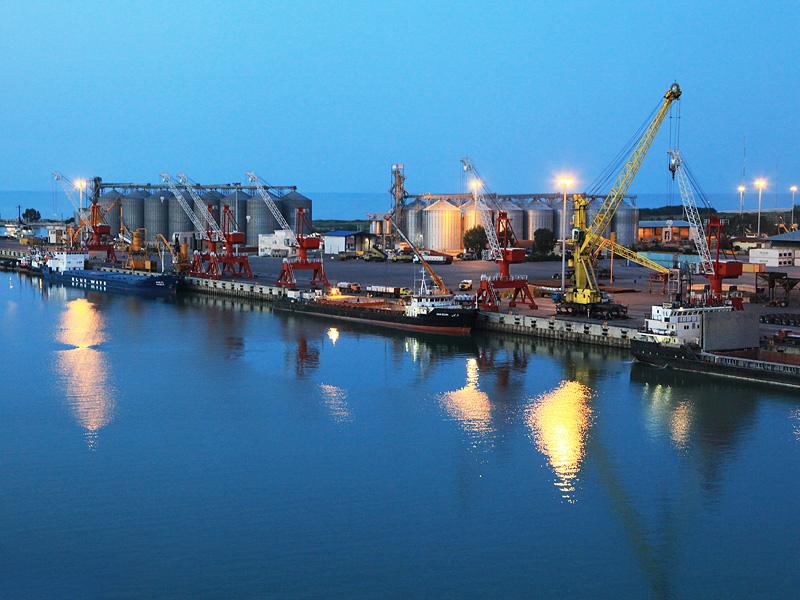
Shahid Rajaei port
Shahid Rajaei port complex, with its unique geographic location, at the closest point to the Strait of Hormuz and the entrance to the Persian Gulf, due to its short distance from the main route of intercontinental traffic of ships, by being located at the intersection of the North-South transit corridor. It is considered the most important import and export gate of the Islamic Republic of Iran.
This huge port complex, which is located in the central point of the southern coast of the country and in Hormozgan province with more than 2 km of sea border, due to being next to the large industries of this province and the country's manufacturing provinces, as well as having infrastructure Suitable for different modes of transportation and connecting to the international network of railways, air and the historical silk road, it has played the biggest role in the transportation industry and exchanges goods and trades with more than 300 famous ports in the world through the world's top 80 container lines. has it.
Shahid Rajaei port complex, with an area of 2400 hectares, has the capacity to receive 70 million tons of goods per year and the capacity to benefit from 36 post berths, having the largest and most advanced container terminal in the country, and after the opening of the second phase of the development plan from It has a capacity of 8 million TEU containers per year and a large volume of general goods handling operations, especially steel products, dry bulk, liquid bulk and crude oil products are carried out in this port.
Imam Khomeini Port
- The closest southern port to the industrial and population centers of the country
- The shortest and most reliable connection bridge with the countries of Iraq, Turkey, the Caucasus and Eastern Europe
- Benefiting from suitable road, rail and air transportation potentials
- Connecting to the network of main transit roads and national railways of the country
- Proximity to Mahshahr, Abadan and Ahvaz airports at distances of 18, 100 and 110 kilometers.
- The most suitable port in the country for the transshipment of goods to the countries of the Persian Gulf
- Having the necessary potential to develop the re-export of goods
- An effective role in the national economy and foreign trade as the second most important port of the country
- The existence of dedicated, container, public terminals, oil products and minerals
- The ability to unload and load Post Panamax container ships (fourth generation) and ships with a capacity of 150 tons
- Benefiting from advanced port and marine equipment in order to provide fast and safe services to ships and goods
- Having a single window system in order to provide centralized services to the customer
- Having an integrated management system (IMS) and an international information security system (ISMS)
- Electronic payment system through the system (PSPOS)
- Having an intelligent truck electronic transfer system (ETT)
Amirabad port
Ports and shipping and special economic zone of Amirabad is located in the east of Mazandaran province and 51 km from the center of the province with geographical coordinates 22 east and 53 north. and potential talents were introduced as a special zone by the Supreme Council of Free Zones, the operating capacity of this port in the first phase is 41 million tons and it is designed for the final phase with a capacity of 36 million tons.
Bushehr seaport
Bushehr port is located at the northern tip of a relatively small peninsula on the coast of the Persian Gulf at a point at the coordinates of 28 degrees 58 minutes north, 50 degrees 50 minutes east. The length of this peninsula is 14 kilometers. The outer anchorage of this port is located at 43 It is located at 50 east longitude and 58 28 north latitude. The water depth in the outer anchorage is 10.8 meters, which leads to the inner anchorage through the outer channel of 9200 meters and from the inner anchorage through the inner channel of 3900 meters to Khor Soltani and the wharf of Bandar Bushehr and from there to Khor Podur. The floor width of the outer channel is 150 meters and the inner channel is up to 140 meters.
The General Administration of Ports and Maritime Affairs of Mazandaran Province, centered on Nowshahr Port, with two commercial ports (Nowshahr and Faridoonkanar) while operating in the field of unloading and loading commercial and petroleum products, is in charge of the implementation of the governance duties of the Ports and Maritime Organization in the matter of maritime safety and security. Maritime surveillance and rescue, establishing maritime telecommunications systems, preserving the marine environment and dealing with sea pollution, observing and applying international conventions in the management of port and maritime affairs, issuing certificates of competency for commercial vessels and maritime birth certificates, registering all vessels for inspection and providing The relevant certificates.
Nowshahr port, with more than 70 years of experience, was launched with the arrival of the first commercial ship carrying parts and machinery of the Karaj iron and steel factory. Nowshahr port, with an area of 45 hectares and having commercial and service docks and suitable land and sea equipment with a depth of 5 meters, annually receives an average of 5 ships from the countries of the Caspian Sea.
Due to the reconstruction and development of the docks of this port, it will reach a depth of 5 meters in the near future, which will allow the entry of ships with higher capacity. This port has the ability to provide services for all types of goods, including general, container, bulk, petroleum products, general goods, barges, water supply to vessels, storage and processing of goods, and the possibility for private sector traders and investors to use the benefits and facilities resulting from the Special Zones Law. Economy was provided.
Port of Astara
The construction of Astara port dates back to 1375. The purpose of building this port in its initial plan was to build a fishing, commercial and passenger port, and based on this plan, two separate ponds, one for the fishing sector, and the other for other uses, while only the first pond should be built. That is, its fishing part was built and used for fishing activities, and the breakwater related to the second pond was left incomplete and half-worked.
After the extinction of the Kilka fish, fishing activities also stopped and the fishing port of Astara practically turned into an abandoned port, and the heavy capital that was spent from the country's public budget for the construction of breakwaters, docks, piers, buildings, dredging, etc. remained unused. And it just became a place for the mooring of Navy frigates. Considering the convenient geographical location of Astara in terms of proximity to the provinces of Zanjan, Azarbaijan (East and West), and Ardabil on the one hand and thinking about the role of the port in urban development in the minds of the officials on the other hand, it was one of the reasons that the necessity of reviving the port in the form of Business-passenger activities intensified. Therefore, based on the Resolution No. 166265/36895 dated 13/12/85 of the honorable government board, the operation of the existing wharves of the province was approved in coordination with the Ministry of Roads and Transportation.
0 views